
Executive Summary
The usefulness and insight that data bring to analytics and decision support is growing at a rapid pace across all major infrastructure vertical markets. The ever-increasing amounts of data being collected has made managing, integrating, and interpreting them to derive meaningful and relevant insights seemingly impossible. The is especially true with new forms of visual and sensor data. What is needed is a way to efficiently put all of the data pieces together so that decision makers and stake holders can see the big picture.
About DOI

The current Z-EYE drone data management solution is being deployed by Department of Interior and has national security implications both with their public data along with their most secure information. This same platform can be customized for any major critical infrastructure client where drone, Geospatial, LIDAR, sensor or any other 3D/4D information is needing to be integrated for better management and efficiency.
Current State:
Data related to assets are disorganized, not in an easy-to-search form, often trapped in silos, and geographically dispersed.
Desired State:
Enable access to all relevant asset information when and where needed.
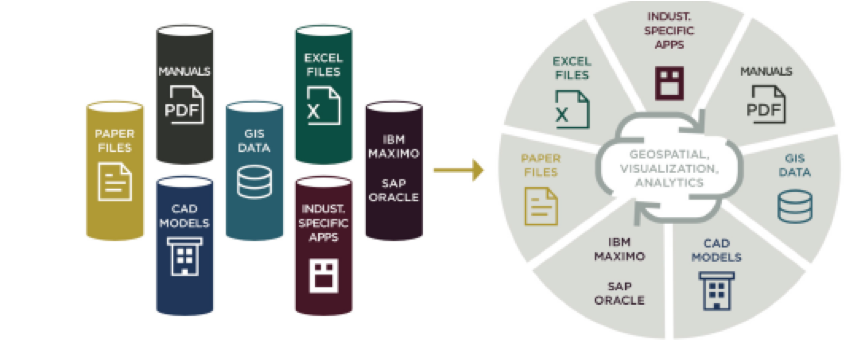
Zivaro has created a highly flexible platform as a service which is a leading solution for bringing together disparate data, creating analytics, machine learning and semantic learning all in a single baseline platform.
The drone data management solution discussed in this use case is targeted at multiple market segments where this platform capabilities and the drone data management solution are extremely applicable and in great demand in data management requests we see exploding in the market.
The Solution Explained
1. Uploading imagery in low bandwidth conditions was one of the first major issues that drone data acquisition companies have had to manage many of the areas where land management and asset management is taking place do not have the ability to have high bandwidth at their finger-tips when uploading or downloading large imagery like drone discovery. Zivaro’s Z Eye drone data management solution allows for these data to be uploaded even when there are breaks in the timing and bandwidth needed to store, upload, download and process the information.
2. AWS Cloud-based imagery storage – With improvements in LIDAR and camera technology, data volumes grow drastically every year. Customers need cost-effective storage for high-resolution visual assets and given the exponential growth in data volume, traditional capacity planning does not work. AWS provides, via its Simple Storage Service (S3) numerous tiers of object storage, supporting a virtually unlimited amount of data storage, and data lifecycle management to allow customers to move less frequently accessed assets to cheaper storage. Organizations no longer need to worry about the durability of their data, and to process their data, they can provision any amount of computing capacity in the same region, securely download and process data in the cloud, uploading their results again for safe keeping. This allows organizations to process data faster, and with a much higher level of information security than before.
3. Image processing including Ortho-rectification and multispectral imagery- Processing imagery and growth that these forms of data bring is completely different than the old relational data that has been managed and processed over the past two decades. Bring these data together into a cohesive data model which allows for all forms of integration and management of the visual data along with tabular data is one of the most important new issues that needed to be solved .In addition to these issues ortho-rectifying disparate imagery and have it all make sense to decision makers, not just geospatial experts, becomes ever more important as this type of data is woven into the data management needs of major infrastructure client. Zivaro has solved this issue along with providing it a platform as a service where ongoing costs are minimized and efficiency in understanding where and what all of your data is key.
4. Advanced search- With growing volumes of data collected across a large number of sites, finding what is relevant and needed becomes difficult, if not impossible. The Z EYE drone data management system has intelligent search capabilities to enable the quick discovery of data. Imagery and metadata are indexed spatially and temporally using knowledge graphs to allow you to see changes to your sites across time. Sensors, flights, raw imagery, processed imagery, metadata, and processing outputs are all connected and searchable within Z EYE.
5. Secure Content sharing – controlling who has access to critical infrastructure data is a top priority in all segments of the market. Critical infrastructure was defined after 9/11 by the federal government and major public and private entities have to be ever mindful of these data to be secure at all times. Zivaro and AWS have created this infrastructure and intelligent platform as a service and can be used by the highest level of secure enterprises in the federal, state and private enterprise segments of the market.